More like 'cjhn82550'
Narrow Results By
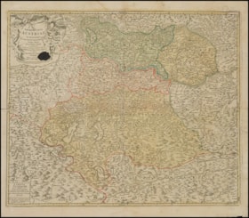
Archiducatus Austriae
https://www.cjhn.ca/link/cjhn113335
- Collection
- MONTREAL HOLOCAUST MUSEUM
- Description Level
- Item
- Material Type
- cartographic material
- Physical Description
- Map : printed ; Ht: 55,8 cm x W: 62,5 cm
- Collection
- MONTREAL HOLOCAUST MUSEUM
- Description Level
- Item
- Material Type
- cartographic material
- Physical Description
- Map : printed ; Ht: 55,8 cm x W: 62,5 cm
- Language
- German
- Latin
- French
- Notes
- Map of Upper Austria; rectangular format; litograph; colored. Places of worship, military and residential areas, waterways and forest areas are all listed. Upper Austria traditionally comprised four administrative regions or districts : the Hausruck, the Inn, the Mühl and the Traun districts. The map was created around 1710 by the cartographer Georg Matthaeus Vischer and published by Johann Baptist Homann. In 1702, Johann Baptist Homann (1664-1724) founded a map-publishing house in Nuremberg, which became one of the most important in 18th-century Germany. Over the following years, he published more than a hundred lithographed maps. His artistic style is characterized by allegorical cartouches and vivid colors. Adele Eisenschiml, born in Vienna in 1879, acquired a number of these old maps, including one by Homann, to add to her collection. The Nazis confiscated this valuable antique from her in 1938. In July 1938, Adele boarded the Arlberg Express in St-Anton to visit her son Georg in Paris. The Gestapo, who accused her of embezzlement, arrested Adele at the Feldkirch border. She was detained for three days and was interrogated by the Gestapo, who stigmatized her for being a member of the Jewish community. Six antique maps, money and jewelry were seized from her. Four of these maps were held at the court in Feldkirch before joining the Vorarlberg archives in 1992. In 2019, Adele's descendants received four of the six cards following a restitution request made by Sheila Murphy, Adele Eisenschiml's great-granddaughter. This was part of a resolution passed by the Voralberg government in 2003 to provide reparations to victims of the Holocaust. The two missing maps were never preserved in the archive’s collection and are still to be found, highlighting, among other things, the many consequences of spoliation. During the Second World War, Germany and its Austrian Nazi supporters exerted pressure for the unification of the two nations. Known as the Anschluss, this annexation was an important step for the Nazi government. The goal was to unite the German and Austrian populations into a single Reich based on self-determination. The Wehrmacht, the army of the Third Reich, entered Austria on March 12, 1938 and began its annexation, violating the Treaty of Versailles and the Treaty of St. Germain. Following this event, Austria ceased to exist as an independent nation until 1945, and antisemitic demonstrations escalated. In addition to public humiliation, antisemitic laws were implemented to restrict the economic and social capital of Jewish communities in Austria.
- Accession No.
- 2021.12.01
- Name Access
- Murphy, Sheila
- Places
- Nuremberg , Germany, Europe
- Archival / Genealogical
- Archival Descriptions
- Repository
- Montreal Holocaust Museum
Images


Blueprint - Jewish National Fund (JNF) Map of Canada Forest
https://www.cjhn.ca/link/cjhn75467
- Collection
- Bloomfield family (Neri and Bernard Bloomfield, Evelyn Schachter) - Zionist activities
- Description Level
- File
- Material Type
- cartographic material
- Fonds No.
- P0247; MC 32-08-09
- Date
- 1950
- Description Level
- File
- Material Type
- cartographic material
- Date
- 1950
- Fonds No.
- P0247
- File No.
- MC 32-08-09
- Notes
- including location of Bloomfield Forest
- Archival / Genealogical
- Archival Descriptions
- Repository
- Canadian Jewish Archives
England and Scotland
https://www.cjhn.ca/link/cjhn59525
- Collection
- Montreal Holocaust Museum
- Description Level
- Item
- Material Type
- cartographic material
- Physical Description
- Map : Paper : Printed, handwritten : Ink : Beige, blue, pink, green, yellow, black, grey. ; Ht: 22 cm x W: 14 cm
- Collection
- Montreal Holocaust Museum
- Description Level
- Item
- Material Type
- cartographic material
- Physical Description
- Map : Paper : Printed, handwritten : Ink : Beige, blue, pink, green, yellow, black, grey. ; Ht: 22 cm x W: 14 cm
- Other Title Information
- Documentary Artifact
- Physical Condition
- Good
- Language
- English
- Notes
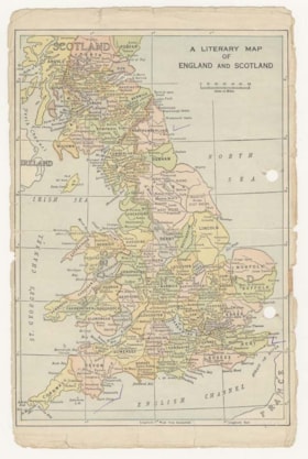
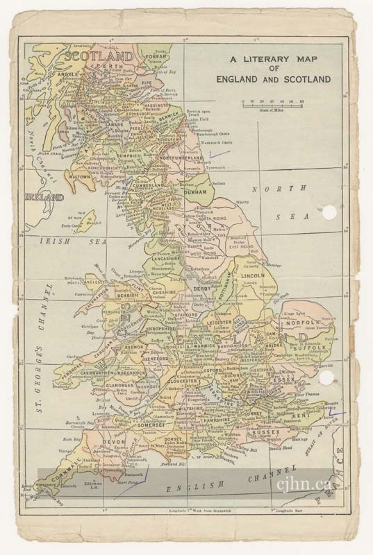
- Page torn from book on right edge, holes punched on right, Literary Map of England. Notes written on back in pencil about how to breakdown a novel and other homework assignments. Narrative: Isaac Herbert Isselbacher was born 1919-11-20 in Isselbach, Germany. His brother was Helmut Isselbacher, born 1921-12-20. Their father was Jacob Isselbacher, born 1883-08-05, to Yitzkhak and Lina. Their mother was Mathilde Loewenstein Isselbacher, born 1893/7/28 to Feist and Rosa. Isaac and Herbert had an uncle and aunt, David and Betty Loewenstein, who lived in New York City with their two children. Isaac left Germany on 1939-07-29, hoping to join his relatives in NYC. He only had the time to get to London, England before the war broke out and he started working in a factory. He was arrested at his workplace as an ‘enemy alien’ and sent to Canada for internment in 1940. Isaac was interned in Camp N in Sherbrooke, Quebec. He was drafted into the Works Program Division for woodworking and net-making. In 1940, he received a last letter from his parents which suggested their imminent deportation. After his release, circa November 1942, Isaac worked as a locksmith. He married Fanny Azeff on 1943-12-26 at the Bnai Jacob synagogue in Montreal. Fanny was born on 1921-12-23 in Canada, the daughter of Mr. and Mrs. Harry Azeff. Isaac was naturalized as a Canadian citizen on 1946-06-08. Fanny was naturalized on 1946-08-30 (she had lost her citizenship by marrying Isaac). Upon learning of his brother’s survival, Isaac travelled to New York in April 1946 to meet with him and their Loewenstein relatives. Afterwards, Helmut travelled to Canada bringing with him a washing machine and bras as late wedding presents for his brother and Fanny. By 1946-08-12, it was discovered that their parents had been killed in Auschwitz, so the two sons inquired into their estate. They received a deed for the land and travelled to the estate to discover that the current owner of their house was their old maid and her son had become the town mayor. Various disputes arose with the current ‘owners’ who believed the Isselbacher family dead. Isaac wished to discuss a settlement, but the mayor’s mother –not realizing Fanny understood German- called the neighbors at work to warn them not to come home as the Isselbacher sons had resurfaced. Payment for the land had reportedly been sent to Israel, though no documentation could be provided.
- Accession No.
- 2011X.167.09
- Name Access
- Issley, Jason
- Places
- England, Europe
- Archival / Genealogical
- Archival Descriptions
- Repository
- Montreal Holocaust Museum
Images


German-Russian Front
https://www.cjhn.ca/link/cjhn48182
- Collection
- Montreal Holocaust Museum
- Description Level
- Item
- Material Type
- cartographic material
- Physical Description
- Map : printed : black, beige, yellow, green
- Date
- 1939-1945
- Collection
- Montreal Holocaust Museum
- Description Level
- Item
- Material Type
- cartographic material
- Physical Description
- Map : printed : black, beige, yellow, green
- Other Title Information
- Documentary Artifact
- Date
- 1939-1945
- Physical Condition
- Good
- Language
- English
- Notes
- Map, printed on newsprint; colour coordinated to correspond with the legend printed at the top right corner. Shows Russia (USSR), land occupied by Russia, Germany, countries occupied by Germany and Italy, as well as neutral countries.
- Accession No.
- 2012X.65.01
- Name Access
- MHMC
- Places
- Germany, Europe
- Archival / Genealogical
- Archival Descriptions
- Repository
- Montreal Holocaust Museum
Images


Jewish Prewar Poland
https://www.cjhn.ca/link/cjhn59570
- Collection
- Montreal Holocaust Museum
- Description Level
- Item
- Material Type
- cartographic material
- Physical Description
- Map : Paper : Printed : Ink : Beige, black. ; Ht: 24 cm x W: 21 cm
- Date
- [Later than 1945]
- Collection
- Montreal Holocaust Museum
- Description Level
- Item
- Material Type
- cartographic material
- Physical Description
- Map : Paper : Printed : Ink : Beige, black. ; Ht: 24 cm x W: 21 cm
- Other Title Information
- Documentary Artifact
- Date
- [Later than 1945]
- Physical Condition
- Good
- Language
- Hebrew
- Notes
- Single-sided page with no creases. Printing blemishes across surface, three locations marked with pen, Piotrkow Trybunalski is marked with an arrow. This is a map of the Jewish pre-war Poland. Narrative: Charles Kotkowsky was born in Piotrkow, Poland, in 1920. He was the son of a butcher, and had three siblings. He tried to immigrate to the USA as the Nazi persecution of Jews began, but he was unable to get the necessary documents in time. Meanwhile, he worked as a tailor in Lodz. The Germans entered Lodz on 1939/9/5 and had set up a ghetto by October. Charles worked in a glass factory, but eventually enlisted to avoid being used for forced labour. The Germans began rounding up Jews around Jewish holidays for labour or small transports for Auschwitz and Treblinka. At this time, he began receiving packages of letters and money from Ignac Samsonowicz, his old Yiddish teacher. The glass factory became a labour camp where Charles and his brother worked until they were sent to Czestochowa labour camp in November 1944. They made bullets in the factory there. The women in the glass factory were sent to Ravensbrück. Later Charles was sent to Buchenwald, where he and his friends were assigned easy jobs because their supervisor was a resistance sympathizer. Charles met Leon Blum before he was moved to Flossenburg. On their last transport train Charles and his brother jumped from the train along with many other Jews (some of which were shot in the attempt) and were sheltered in a Czechoslovakian town until the American army arrived. He moved to Italy where he worked as a translator, mostly in doctor's offices. He moved to Canada in 1951.He married Sally Blum, and they had two children, Pearl Levine and Rickie Cohen. Charles died from cancer on 2003/2/8 in Toronto, Canada.
- Accession No.
- 1998.7.213
- Name Access
- Kotkowsky, Charles
- Places
- Poland, Europe
- Archival / Genealogical
- Archival Descriptions
- Repository
- Montreal Holocaust Museum
Images


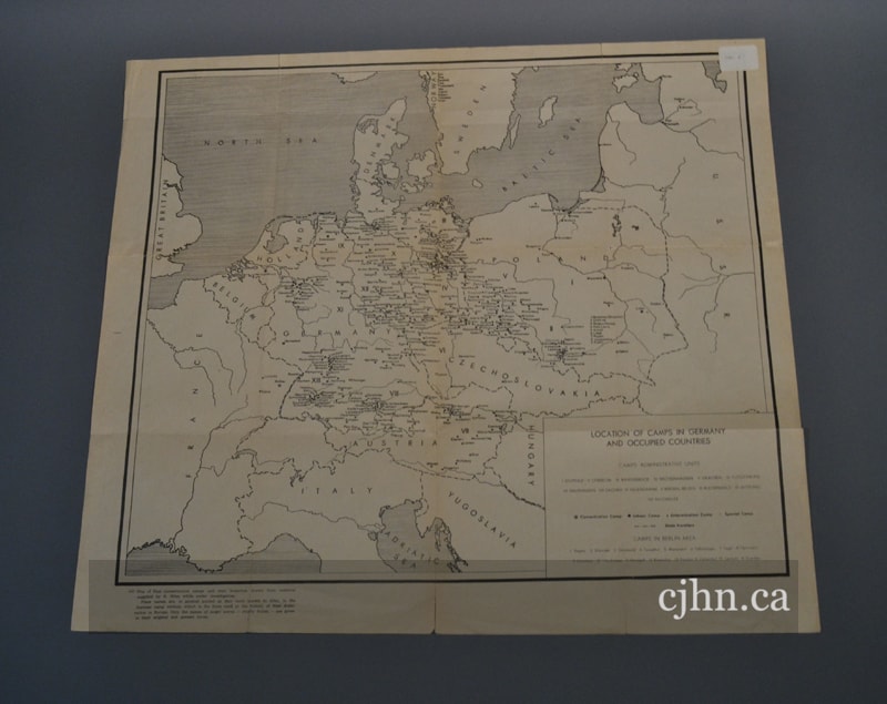
Location of Camps in Germany and Occupied Countries
https://www.cjhn.ca/link/cjhn48183
- Collection
- Montreal Holocaust Museum
- Description Level
- Item
- Material Type
- cartographic material
- Physical Description
- Map : Printed : Beige, black
- Collection
- Montreal Holocaust Museum
- Description Level
- Item
- Material Type
- cartographic material
- Physical Description
- Map : Printed : Beige, black
- Other Title Information
- Documentary Artifact
- Physical Condition
- Poor
- Language
- English
- German
- Polish
- Notes
- Map, printed on newsprint; b&w. Shows the location of the different camps in Germany and the occupied countries; a legend is printed at the bottom right corner.
- Accession No.
- 2012X.66.01
- Name Access
- MHMC
- Places
- Europe
- Archival / Genealogical
- Archival Descriptions
- Repository
- Montreal Holocaust Museum
Images


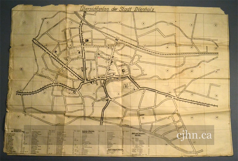
Map
https://www.cjhn.ca/link/cjhn78465
- Collection
- Montreal Holocaust Museum
- Description Level
- Item
- Material Type
- cartographic material
- Physical Description
- Map : Paper : printed : Ink : beige, black ; Ht: 62 cm x W: 90,5 cm
- Date
- 1939-1945
- Collection
- Montreal Holocaust Museum
- Description Level
- Item
- Material Type
- cartographic material
- Physical Description
- Map : Paper : printed : Ink : beige, black ; Ht: 62 cm x W: 90,5 cm
- Other Title Information
- Documentary Artifact
- Date
- 1939-1945
- Physical Condition
- Good
- Language
- German
- Notes
- 1 page. One-sided map of the city Diepholz. The document shows the main street of the town and was used by German soldiers to identify their surroundings. On the b. is a legend. Narrative: Henry Yall Fowler was a volunteer for the Canadian Military Engineers. He was posted in Netherlands and United Kingdom during the Second World War. During his service in Holland, he found this map in a German tank.
- Accession No.
- 2015.02.02
- Name Access
- Fowler, Arthur
- Places
- Diepholz, Germany, Europe
- Archival / Genealogical
- Archival Descriptions
- Repository
- Montreal Holocaust Museum
Images


Map
https://www.cjhn.ca/link/cjhn113345
- Collection
- MONTREAL HOLOCAUST MUSEUM
- Description Level
- Item
- Material Type
- cartographic material
- Physical Description
- Map : printed ; Ht: 80,1 cm x W: 56,8 cm
- Collection
- MONTREAL HOLOCAUST MUSEUM
- Description Level
- Item
- Material Type
- cartographic material
- Physical Description
- Map : printed ; Ht: 80,1 cm x W: 56,8 cm
- Language
- German
- Notes
- Map of surroudings of Lichtenfels, Bavaria (c.1820). Inscribed by Augustin Christoph Hannbaumb and Konigl Kauptmann, in Bamberg. In 1702, Johann Baptist Homann (1664-1724) founded a map-publishing house in Nuremberg, which became one of the most important in 18th-century Germany. Over the following years, he published more than a hundred lithographed maps. His artistic style is characterized by allegorical cartouches and vivid colors. Adele Eisenschiml, born in Vienna in 1879, acquired a number of these old maps, including one by Homann, to add to her collection. The Nazis confiscated this valuable antique from her in 1938. In July 1938, Adele boarded the Arlberg Express in St-Anton to visit her son Georg in Paris. The Gestapo, who accused her of embezzlement, arrested Adele at the Feldkirch border. She was detained for three days and was interrogated by the Gestapo, who stigmatized her for being a member of the Jewish community. Six antique maps, money and jewelry were seized from her. Four of these maps were held at the court in Feldkirch before joining the Vorarlberg archives in 1992. In 2019, Adele's descendants received four of the six cards following a restitution request made by Sheila Murphy, Adele Eisenschiml's great-granddaughter. This was part of a resolution passed by the Voralberg government in 2003 to provide reparations to victims of the Holocaust. The two missing maps were never preserved in the archive’s collection and are still to be found, highlighting, among other things, the many consequences of spoliation. During the Second World War, Germany and its Austrian Nazi supporters exerted pressure for the unification of the two nations. Known as the Anschluss, this annexation was an important step for the Nazi government. The goal was to unite the German and Austrian populations into a single Reich based on self-determination. The Wehrmacht, the army of the Third Reich, entered Austria on March 12, 1938 and began its annexation, violating the Treaty of Versailles and the Treaty of St. Germain. Following this event, Austria ceased to exist as an independent nation until 1945, and antisemitic demonstrations escalated. In addition to public humiliation, antisemitic laws were implemented to restrict the economic and social capital of Jewish communities in Austria.
- Accession No.
- 2021.12.02
- Name Access
- Murphy, Sheila
- Places
- Bamberg, Germany, Europe
- Archival / Genealogical
- Archival Descriptions
- Repository
- Montreal Holocaust Museum
Images


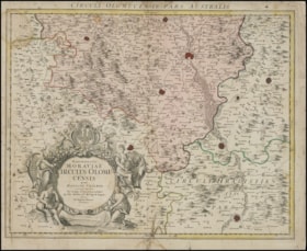
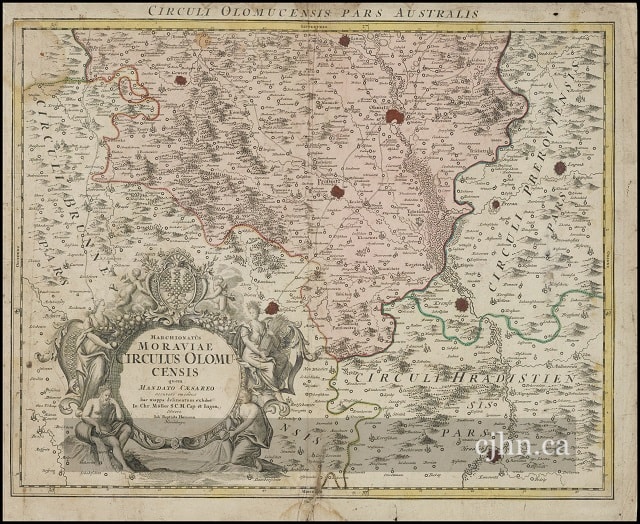
Marchionatûs Moraviae Circulus Olomuscensis
https://www.cjhn.ca/link/cjhn113346
- Collection
- MONTREAL HOLOCAUST MUSEUM
- Description Level
- Item
- Material Type
- cartographic material
- Physical Description
- Map : printed ; Ht: 51,2 cm x W: 62,5 cm
- Collection
- MONTREAL HOLOCAUST MUSEUM
- Description Level
- Item
- Material Type
- cartographic material
- Physical Description
- Map : printed ; Ht: 51,2 cm x W: 62,5 cm
- Language
- Latin
- Notes
- Map of surroundings of Olomuc, Moravia. This map presents a sketch of Müller S.C.M. Edited by Johann Baptist Homann. In 1702, Johann Baptist Homann (1664-1724) founded a map-publishing house in Nuremberg, which became one of the most important in 18th-century Germany. Over the following years, he published more than a hundred lithographed maps. His artistic style is characterized by allegorical cartouches and vivid colors. Adele Eisenschiml, born in Vienna in 1879, acquired a number of these old maps, including one by Homann, to add to her collection. The Nazis confiscated this valuable antique from her in 1938. In July 1938, Adele boarded the Arlberg Express in St-Anton to visit her son Georg in Paris. The Gestapo, who accused her of embezzlement, arrested Adele at the Feldkirch border. She was detained for three days and was interrogated by the Gestapo, who stigmatized her for being a member of the Jewish community. Six antique maps, money and jewelry were seized from her. Four of these maps were held at the court in Feldkirch before joining the Vorarlberg archives in 1992. In 2019, Adele's descendants received four of the six cards following a restitution request made by Sheila Murphy, Adele Eisenschiml's great-granddaughter. This was part of a resolution passed by the Voralberg government in 2003 to provide reparations to victims of the Holocaust. The two missing maps were never preserved in the archive’s collection and are still to be found, highlighting, among other things, the many consequences of spoliation. During the Second World War, Germany and its Austrian Nazi supporters exerted pressure for the unification of the two nations. Known as the Anschluss, this annexation was an important step for the Nazi government. The goal was to unite the German and Austrian populations into a single Reich based on self-determination. The Wehrmacht, the army of the Third Reich, entered Austria on March 12, 1938 and began its annexation, violating the Treaty of Versailles and the Treaty of St. Germain. Following this event, Austria ceased to exist as an independent nation until 1945, and antisemitic demonstrations escalated. In addition to public humiliation, antisemitic laws were implemented to restrict the economic and social capital of Jewish communities in Austria.
- Accession No.
- 2021.12.03
- Name Access
- Murphy, Sheila
- Places
- Nuremberg, Germany, Europe
- Archival / Genealogical
- Archival Descriptions
- Repository
- Montreal Holocaust Museum
Images

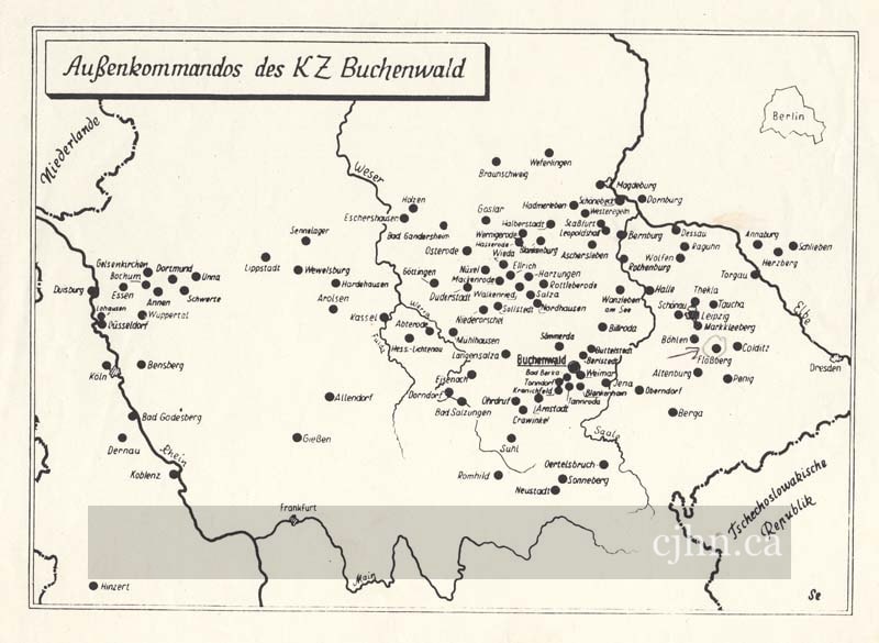
Outposts of the concentration camp Buchenwald
https://www.cjhn.ca/link/cjhn59569
- Collection
- Montreal Holocaust Museum
- Description Level
- Item
- Material Type
- cartographic material
- Physical Description
- Map : Paper : Printed : Ink : White, black ; Ht: 21 cm x W: 28 cm
- Collection
- Montreal Holocaust Museum
- Description Level
- Item
- Material Type
- cartographic material
- Physical Description
- Map : Paper : Printed : Ink : White, black ; Ht: 21 cm x W: 28 cm
- Other Title Information
- Documentary Artifact
- Physical Condition
- Good
- Language
- German
- Notes
- Single sided page with map of Germany printed on front. Map shows all outposts of the concentration camp Buchenwald. Flossenburg, the camp Charles was sent to after Buchenwald, is indicated with an arrow. Narrative: Charles Kotkowsky was born in Piotrkow, Poland, in 1920. He was the son of a butcher, and had three siblings. He tried to immigrate to the USA as the Nazi persecution of Jews began, but he was unable to get the necessary documents in time. Meanwhile, he worked as a tailor in Lodz. The Germans entered Lodz on 1939/9/5 and had set up a ghetto by October. Charles worked in a glass factory, but eventually enlisted to avoid being used for forced labour. The Germans began rounding up Jews around Jewish holidays for labour or small transports for Auschwitz and Treblinka. At this time, he began receiving packages of letters and money from Ignac Samsonowicz, his old Yiddish teacher. The glass factory became a labour camp where Charles and his brother worked until they were sent to Czestochowa labour camp in November 1944. They made bullets in the factory there. The women in the glass factory were sent to Ravensbrück. Later Charles was sent to Buchenwald, where he and his friends were assigned easy jobs because their supervisor was a resistance sympathizer. Charles met Leon Blum before he was moved to Flossenburg. On their last transport train Charles and his brother jumped from the train along with many other Jews (some of which were shot in the attempt) and were sheltered in a Czechoslovakian town until the American army arrived. He moved to Italy where he worked as a translator, mostly in doctor's offices. He moved to Canada in 1951.He married Sally Blum, and they had two children, Pearl Levine and Rickie Cohen. Charles died from cancer on 2003/2/8 in Toronto, Canada.
- Accession No.
- 1998.7.212
- Name Access
- Kotkowsky, Charles
- Places
- Germany, Europe
- Archival / Genealogical
- Archival Descriptions
- Repository
- Montreal Holocaust Museum
Images

Philips’ War Map of the World
https://www.cjhn.ca/link/cjhn48184
- Collection
- Montreal Holocaust Museum
- Description Level
- Item
- Material Type
- cartographic material
- Physical Description
- Map : printed : beige, green, black, white, brown, blue, red, purple, yellow, orange, pink
- Date
- 1941
- Collection
- Montreal Holocaust Museum
- Description Level
- Item
- Material Type
- cartographic material
- Physical Description
- Map : printed : beige, green, black, white, brown, blue, red, purple, yellow, orange, pink
- Other Title Information
- Documentary Artifact
- Date
- 1941
- Physical Condition
- Poor
- Language
- English
- Notes
- Map of the world, folded like a booklet with the title and publishing information printed on the front panel. Each country is colour coordinated, depending on their role in the war; many curved lines connect different countries/cities/continents; a legend is printed at the bottom left corner, explaining the colours and lines found on the map.
- Accession No.
- 2012X.67.01
- Name Access
- MHMC
- Archival / Genealogical
- Archival Descriptions
- Repository
- Montreal Holocaust Museum
Images


Photographs
https://www.cjhn.ca/link/cjhn89991
- Collection
- Adele Druckman-Kinsbrunner Fonds
- Description Level
- Fonds
- Material Type
- textual record
- cartographic material
- Physical Description
- 1 file of textual records.
- Fonds No.
- 1416; 00009
- Scope and Content
- Contains a photograph of the B'nai Brith bowling league at the Mount Royal Lodge, photos of Sidney Brown, Jessie Cohen, and unidentified relatives from Eastern Europe.
- Collection
- Adele Druckman-Kinsbrunner Fonds
- Description Level
- Fonds
- Material Type
- textual record
- cartographic material
- Physical Description
- 1 file of textual records.
- Scope and Content
- Contains a photograph of the B'nai Brith bowling league at the Mount Royal Lodge, photos of Sidney Brown, Jessie Cohen, and unidentified relatives from Eastern Europe.
- Fonds No.
- 1416
- File No.
- 00009
- Storage Location
- JPL
- Ctn. 001
- Physical Condition
- Fair
- Language
- English
- Accession No.
- 19-005
- Archival / Genealogical
- Archival Descriptions
- Repository
- Jewish Public Library Archives
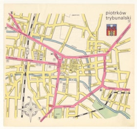
Piotrkow Trybunalski
https://www.cjhn.ca/link/cjhn59568
- Collection
- Montreal Holocaust Museum
- Description Level
- Item
- Material Type
- cartographic material
- Physical Description
- Map : Paper : Printed : Ink : Pink, blue, beige, green ; Ht: 19 cm x W: 20 cm
- Collection
- Montreal Holocaust Museum
- Description Level
- Item
- Material Type
- cartographic material
- Physical Description
- Map : Paper : Printed : Ink : Pink, blue, beige, green ; Ht: 19 cm x W: 20 cm
- Other Title Information
- Documentary Artifact
- Physical Condition
- Good
- Language
- Polish
- Notes
- Double sided page, no creases, tear down left side where page was torn from source. Coloured street map of Piotrkow Trybunalski. On the back, tourist destinations indicated with contact information, legend, and address. The house of Charles Kotkowsky is marked with pen arrow. Narrative: Charles Kotkowsky was born in Piotrkow, Poland, in 1920. He was the son of a butcher, and had three siblings. He tried to immigrate to the USA as the Nazi persecution of Jews began, but he was unable to get the necessary documents in time. Meanwhile, he worked as a tailor in Lodz. The Germans entered Lodz on 1939/9/5 and had set up a ghetto by October. Charles worked in a glass factory, but eventually enlisted to avoid being used for forced labour. The Germans began rounding up Jews around Jewish holidays for labour or small transports for Auschwitz and Treblinka. At this time, he began receiving packages of letters and money from Ignac Samsonowicz, his old Yiddish teacher. The glass factory became a labour camp where Charles and his brother worked until they were sent to Czestochowa labour camp in November 1944. They made bullets in the factory there. The women in the glass factory were sent to Ravensbrück. Later Charles was sent to Buchenwald, where he and his friends were assigned easy jobs because their supervisor was a resistance sympathizer. Charles met Leon Blum before he was moved to Flossenburg. On their last transport train Charles and his brother jumped from the train along with many other Jews (some of which were shot in the attempt) and were sheltered in a Czechoslovakian town until the American army arrived. He moved to Italy where he worked as a translator, mostly in doctor's offices. He moved to Canada in 1951.He married Sally Blum, and they had two children, Pearl Levine and Rickie Cohen. Charles died from cancer on 2003/2/8 in Toronto, Canada.
- Accession No.
- 1998.7.211
- Name Access
- Kotkowsky, Charles
- Archival / Genealogical
- Archival Descriptions
- Repository
- Montreal Holocaust Museum
Images


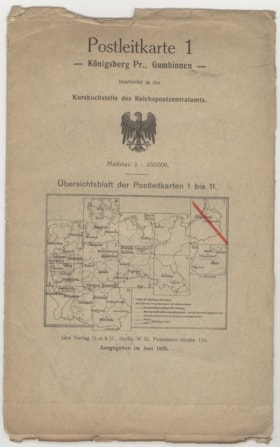
Postleikarte 1-Königsberg Pr., Gumbinnen
https://www.cjhn.ca/link/cjhn59974
- Collection
- Montreal Holocaust Museum
- Description Level
- Item
- Material Type
- cartographic material
- Physical Description
- Map : paper : White, black, orange, blue, yellow
- Date
- June 01, 1935
- Collection
- Montreal Holocaust Museum
- Description Level
- Item
- Material Type
- cartographic material
- Physical Description
- Map : paper : White, black, orange, blue, yellow
- Other Title Information
- Documentary Artifact
- Date
- June 01, 1935
- Physical Condition
- Good
- Language
- German
- Notes
- Map of Nazi Germany territories with legend across the bottom. Scale is 1:450000. There is a Reichsadler of the Weimar Republic in the centre of the front cover, as well as a Map divided into 11 sections, section 1 has a diagonal line through it, indicating that that map is inside. Map is folded in 4 vertical folds, 2 horizontal folds.
- Accession No.
- 2013.02.13
- Name Access
- Strickler, Cornelia
- Places
- Berlin, Germany , Europe
- Archival / Genealogical
- Archival Descriptions
- Repository
- Montreal Holocaust Museum
Images

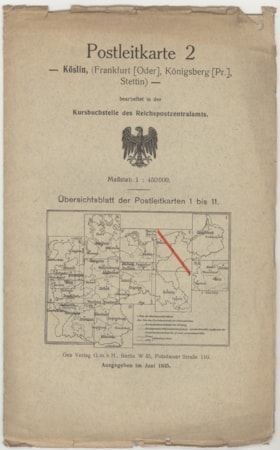
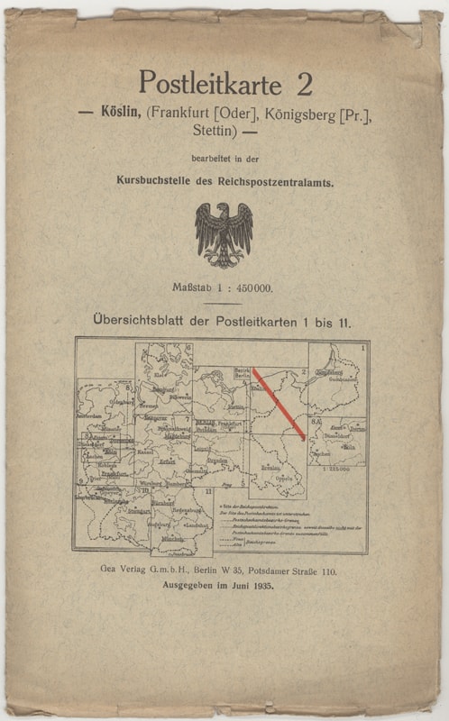
Postleikarte 2- Köslin, (Frankfurt [Oder], Königsberg [Pr.], Stettin)
https://www.cjhn.ca/link/cjhn59975
- Collection
- Montreal Holocaust Museum
- Description Level
- Item
- Material Type
- cartographic material
- Physical Description
- Map : paper : White, black, orange, blue, yellow
- Date
- June 01, 1935
- Collection
- Montreal Holocaust Museum
- Description Level
- Item
- Material Type
- cartographic material
- Physical Description
- Map : paper : White, black, orange, blue, yellow
- Other Title Information
- Documentary Artifact
- Date
- June 01, 1935
- Physical Condition
- Good
- Language
- German
- Notes
- Map of Nazi Germany territories with legend across the bottom. Scale is 1:450000. There is a Reichsadler of the Weimar Republic in the centre of the front cover, as well as a Map divided into 11 sections, section 2 has a diagonal line through it, indicating that that map is inside. Map is folded in 4 vertical folds, 3 horizontal folds.
- Accession No.
- 2013.02.14
- Name Access
- Strickler, Cornelia
- Places
- Berlin, Germany , Europe
- Archival / Genealogical
- Archival Descriptions
- Repository
- Montreal Holocaust Museum
Images

Postleikarte 3- Breslau, Oppeln, Troppaw, Posen, (Aussig, Frankfurt [Oder])
https://www.cjhn.ca/link/cjhn59967
- Collection
- Montreal Holocaust Museum
- Description Level
- Item
- Material Type
- cartographic material
- Physical Description
- Map : paper : White, black, orange, blue, yellow
- Date
- 1941
- Collection
- Montreal Holocaust Museum
- Description Level
- Item
- Material Type
- cartographic material
- Physical Description
- Map : paper : White, black, orange, blue, yellow
- Other Title Information
- Documentary Artifact
- Date
- 1941
- Physical Condition
- Good
- Language
- German
- Notes
- Map of Nazi Germany territories with legend across the bottom. Scale is 1:450000. There is a Reichsadler of Nazi Germany in the centre of the front cover, as well as a map divided into 13 sections, section 3 has a diagonal line through it, indicating that that map is inside. Map is folded in 4 vertical folds, 3 horizontal folds.
- Accession No.
- 2013.02.06
- Name Access
- Strickler, Cornelia
- Places
- Berlin, Germany , Europe
- Archival / Genealogical
- Archival Descriptions
- Repository
- Montreal Holocaust Museum
Images

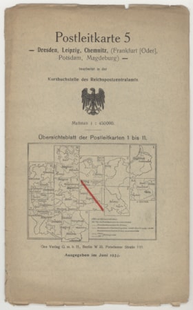
Postleikarte 5- Dresden, Leipzig, Chemnitz, (Frankfurt [Oder], Potsdam, Magdeburg)
https://www.cjhn.ca/link/cjhn59976
- Collection
- Montreal Holocaust Museum
- Description Level
- Item
- Material Type
- cartographic material
- Physical Description
- Map : paper : White, black, orange, blue, yellow
- Date
- June 01, 1934
- Collection
- Montreal Holocaust Museum
- Description Level
- Item
- Material Type
- cartographic material
- Physical Description
- Map : paper : White, black, orange, blue, yellow
- Other Title Information
- Documentary Artifact
- Date
- June 01, 1934
- Physical Condition
- Good
- Language
- German
- Notes
- Map of Nazi Germany territories with legend across the bottom. Scale is 1:450000. There is a Reichsadler of the Weimar Republic in the centre of the front cover, as well as a Map divided into 11 sections, section 5 has a diagonal line through it, indicating that that map is inside. Map is folded in 4 vertical folds, 3 horizontal folds.
- Accession No.
- 2013.02.15
- Name Access
- Strickler, Cornelia
- Places
- Berlin, Germany , Europe
- Archival / Genealogical
- Archival Descriptions
- Repository
- Montreal Holocaust Museum
Images


Postleikarte 5- Dresden, Leipzig, Chemnitz, Karlsbad, Aussig, (Frankfurt [Oder], Potsdam, Breslau, Magdeburg)
https://www.cjhn.ca/link/cjhn59968
- Collection
- Montreal Holocaust Museum
- Description Level
- Item
- Material Type
- cartographic material
- Physical Description
- Map : paper : White, black, orange, blue, yellow
- Date
- June 01, 1939
- Collection
- Montreal Holocaust Museum
- Description Level
- Item
- Material Type
- cartographic material
- Physical Description
- Map : paper : White, black, orange, blue, yellow
- Other Title Information
- Documentary Artifact
- Date
- June 01, 1939
- Physical Condition
- Good
- Language
- German
- Notes
- Map of Nazi Germany territories with legend across the bottom. Scale is 1:450000. There is a Reichsadler of Nazi Germany in the centre of the front cover, as well as a map divided into 11 sections, section 5 has a diagonal line through it, indicating that that map is inside. Map is folded in 4 vertical folds, 3 horizontal folds.
- Accession No.
- 2013.02.07
- Name Access
- Strickler, Cornelia
- Places
- Berlin, Germany , Europe
- Archival / Genealogical
- Archival Descriptions
- Repository
- Montreal Holocaust Museum
Images

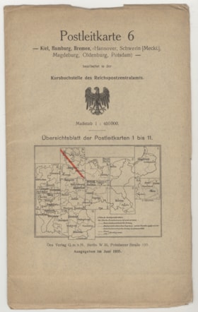
Postleikarte 6- Kiel, Hamburg, Bremen, (Hannover, Schwerin [Meckl.], Magdeburg, Oldenburg, Potsdam)
https://www.cjhn.ca/link/cjhn59970
- Collection
- Montreal Holocaust Museum
- Description Level
- Item
- Material Type
- cartographic material
- Physical Description
- Map : paper : White, black, orange, blue, yellow
- Date
- June 01, 1935
- Collection
- Montreal Holocaust Museum
- Description Level
- Item
- Material Type
- cartographic material
- Physical Description
- Map : paper : White, black, orange, blue, yellow
- Other Title Information
- Documentary Artifact
- Date
- June 01, 1935
- Physical Condition
- Good
- Language
- German
- Notes
- Map of Nazi Germany territories with legend across the bottom. Scale is 1:450000. There is a Reichsadler of the Weimar Republic in the centre of the front cover, as well as a Map divided into 11 sections, section 6 has a diagonal line through it, indicating that that map is inside. Map is folded in 4 vertical folds, 3 horizontal folds.
- Accession No.
- 2013.02.09
- Name Access
- Strickler, Cornelia
- Places
- Berlin, Germany , Europe
- Archival / Genealogical
- Archival Descriptions
- Repository
- Montreal Holocaust Museum
Images

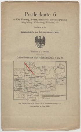
Postleikarte 6- Kiel, Hamburg, Bremen, (Hannover, Schwerin [Meckl.], Magdeburg, Oldenburg, Potsdamn)
https://www.cjhn.ca/link/cjhn59969
- Collection
- Montreal Holocaust Museum
- Description Level
- Item
- Material Type
- cartographic material
- Physical Description
- Map : paper : White, black, orange, blue, yellow
- Date
- June 01, 1935
- Collection
- Montreal Holocaust Museum
- Description Level
- Item
- Material Type
- cartographic material
- Physical Description
- Map : paper : White, black, orange, blue, yellow
- Other Title Information
- Documentary Artifact
- Date
- June 01, 1935
- Physical Condition
- Good
- Language
- German
- Notes
- Map of Nazi Germany territories with legend across the bottom. Scale is 1:450000. There is a Reichsadler of the Weimar Republic in the centre of the front cover, as well as a Map divided into 11 sections, section 6 has a diagonal line through it, indicating that that map is inside. Map is folded in 4 vertical folds, 3 horizontal folds.
- Accession No.
- 2013.02.08
- Name Access
- Strickler, Cornelia
- Places
- Berlin, Germany , Europe
- Archival / Genealogical
- Archival Descriptions
- Repository
- Montreal Holocaust Museum
Images

{{ server.message }}